
PDS Severe Thunderstorm Watch: What It Really Means and Why You Should Take It Seriously
insoduction
Meta Description: A PDS severe thunderstorm watch signals extreme danger from powerful storms. Learn what it means, how it differs from a regular watch, and how to stay safe when one is issued.
If you have ever seen the letters “PDS” attached to a severe thunderstorm watch and wondered what makes it different from a regular watch, you are not alone. Most people scroll past weather alerts without a second thought. But when you see PDS attached to a watch, it is worth stopping and paying attention. This label does not show up often, and when it does, it means forecasters see something in the atmosphere that worries them enough to raise the alarm louder than usual.
In this article, you will learn exactly what a PDS severe thunderstorm watch is, why it gets issued, how it differs from a standard watch, and what steps you should take to protect yourself and your family when one covers your area.
What Does PDS Stand For?
PDS stands for Particularly Dangerous Situation. The National Weather Service’s Storm Prediction Center, based in Norman, Oklahoma, adds this tag to a watch when it expects an outbreak of severe weather that goes well beyond typical storm activity. You will not see this label attached to every storm system. Forecasters reserve it for situations where the risk to life and property climbs sharply above normal.
Think of it this way. A regular severe thunderstorm watch tells you that conditions favor dangerous storms in your area. A PDS severe thunderstorm watch tells you that conditions favor an extreme, potentially historic event. The difference comes down to scale and intensity.
What Makes a PDS Severe Thunderstorm Watch Different
A standard severe thunderstorm watch gets issued when the atmosphere supports storms capable of producing hail at least one inch in diameter or winds reaching 58 miles per hour. Those are already serious numbers. Now raise the stakes.
When forecasters upgrade a watch to PDS status, they usually expect one or more of the following:
- Widespread damaging winds, often associated with a derecho, which is a long line of fast moving thunderstorms that can flatten trees and power lines across hundreds of miles
- Extremely large hail, frequently over two inches in diameter, large enough to shatter windshields and dent vehicles
- A higher chance of embedded tornadoes forming within the storm line, sometimes with little advance warning
You can see why forecasters do not hand out this label casually. It signals that the setup in the atmosphere lines up with the kind of conditions that have produced major, damaging weather events in the past.
How Rare Is a PDS Watch
PDS watches are uncommon by design. The Storm Prediction Center only applies the tag when confidence runs high and the expected impact reaches a serious threshold. Most severe weather seasons pass with only a handful of these watches issued across the entire country.
That rarity is part of the message. Meteorologists want the public to understand that this is not a routine storm day. When you see PDS attached to an alert, treat it as a signal that today’s weather deserves your full attention, not a passing glance at your phone.
PDS Severe Thunderstorm Watch vs PDS Tornado Watch
You might also come across a PDS tornado watch, and it is easy to confuse the two. Both use the same PDS label, but they point to different primary threats.
A PDS tornado watch means forecasters expect multiple strong or violent tornadoes within the watch area. A PDS severe thunderstorm watch focuses more on widespread wind damage and giant hail, though it can still include the risk of tornadoes forming inside the storm complex. In short, both types raise the alarm, but the headline threat can shift depending on which one gets issued.
Why Forecasters Use This Label
Weather warnings work best when people respond appropriately. If every storm gets the same urgent tone, people start tuning out the message, a problem meteorologists call warning fatigue. The PDS label exists to cut through that noise. It tells you clearly that this event stands apart from routine severe weather.
Research on public response to weather alerts backs this up. Studies looking at forecaster communication have found that PDS wording helps identify a higher share of dangerous, high impact events compared to standard watches. That extra layer of language gives you a better sense of how seriously to take the threat heading your way.
What You Should Do When a PDS Watch Is Issued
Once you know a PDS severe thunderstorm watch covers your area, shift into preparation mode right away. Here is how you can stay ahead of the danger.
Monitor alerts closely. Keep a weather radio, phone app, or local news source active so you catch updates as the situation develops. Storms tied to PDS watches can intensify quickly.
Secure loose items outside. Patio furniture, trampolines, grills, and anything else that can catch wind should go into a garage or shed. High winds turn ordinary objects into dangerous projectiles.
Identify your safe space now. Choose an interior room on the lowest floor, away from windows, before the storm arrives. Waiting until the sky turns green to figure this out wastes precious time.
Charge your devices. Power outages often follow storms capable of producing derecho level winds. A charged phone keeps you connected to alerts and emergency services if the power goes out.
Avoid unnecessary travel. If you can postpone a drive until the watch expires, do it. Falling trees, downed power lines, and flooded roads create serious hazards during and after these events.
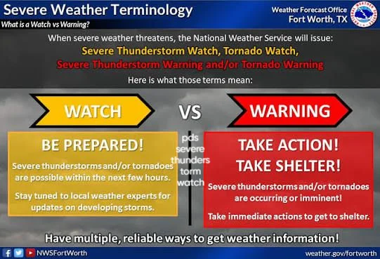
Watch for warnings, not just watches. A watch means conditions favor severe weather. A warning means a storm has actually been detected and danger is imminent in your specific location. Stay alert so you can react fast if a warning gets issued for your area.
How Long Does a PDS Watch Typically Last
Like standard severe thunderstorm watches, a PDS watch usually stays in effect for four to eight hours, though the exact duration depends on how long forecasters expect the threat to persist across the watch area. The Storm Prediction Center can extend, reissue, or cancel the watch early depending on how the storms actually develop, so keep checking for updates rather than assuming the original timeframe will hold.
Real World Impact of PDS Watches
PDS severe thunderstorm watches often precede some of the most damaging non tornadic weather events in the country. Derechos tied to these watches have knocked out power to millions of people at once and caused damage comparable to a hurricane, all within a matter of hours. Because these storms move fast and cover huge distances, the destruction spreads across multiple states in a single afternoon or evening.
That is exactly why the label matters so much. A slow moving storm gives you time to react. A fast moving line of severe storms tied to a PDS watch can move through your area before you realize how quickly conditions changed.
Final Thoughts
A PDS severe thunderstorm watch is not just another weather alert scrolling across your screen. It represents a clear signal from meteorologists that the atmosphere is primed for an extreme, high impact event. Whenever you see this label, take it as your cue to prepare immediately rather than wait and see. Secure your surroundings, know where you will shelter, and stay tuned to updates until the threat passes.
Storms tied to PDS watches move fast and hit hard, but a little preparation goes a long way. Taking these alerts seriously today could make all the difference for your safety tomorrow.